This article was originally published on www.shiphandlingpro.com, reshared here on Marine-pilots.com
Today I will discuss a very simple and useful practical trick often used by pilots.
When we have to berth a vessel with small clearances forward and aft (say 20 to 25 mtr fwd and aft) it is very essential that you are able to estimate your position. Now most of the time you have a berthing supervisor on jetty who will help you with position. In addition you can inform your fwd and aft crew to give you clearances while vessel is being moved laterally towards the berth with small for and aft clearance.
But it can have following issues:
1. Estimate of your fwd and aft crew or berthing supervisor can be very vague at times and may cause you unnecessary concern and anxiety.
2. When vessel is not parallel to berth the position given by Berthing supervisor may not be correct.
I often find new pilots getting agitated and anxious in such scenario and loosing their concentration
Hence a proactive pilot will not entirely depend upon above feeds but will know his position fairly accurately by checking his bridge position.
So here we will look at systematic approach
First step is to calculate your final bridge position at berth.
1. For tanker, you can check your manifold to bridge distance and you can calculate what will be your bridge position wrt fixed objects on jetty i.e. mooring dolphins. Usually all pilots have access to berth drawings and they should know the distances between dolphins, so that they can calculate that bridge will be roughly ahead or behind of breast dolphin by so many meters.
2. For dry vessels generally berthing positions is given wrt to Panels/bollards. Pilot will have information about distance between bollards, and he can calculate his bridge position. Ex: A vl LOA 200 mtr is given berthing posn between Bollards 115 to 125 Distance between bollards is 20 mtr. From Vl bridge wing marking, we can find out bow to bridge distance is 160 mtr. So we know that bridge will be in line with bollard Number 123 ( from 115 to 123, 8 bollards with 20 mtr gap each i.e. 160 mtr)
3. Or if available Berthing supervisor can place Bridge Marker cones.
4. Now if berth alignment is 110-290. So the line 90 deg from berth alignment is 200. So Whenever you look at your bridge wing gyro repeater at 200 deg direction, you will exactly see your present bridge position.This will always give your correct bridge position irrespective of your heading. As can be seen in below picture.
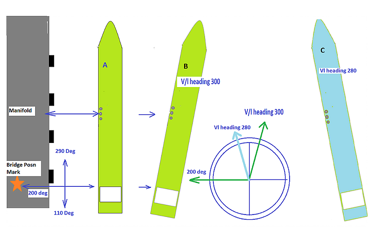
Graphic by Capt. Girish Chandra
Graphic by Capt. Girish Chandra
One can also plan his Limits of bridge position something similar to NMT and NLT in chartwork and navigation. Eg. If bridge position is at bollard 122 or forward of it, that means Bow is not yet clear of vl ahead, or if bridge posn is at 124 of behind it, that means vl stern is still not clear from vessel behind hence in both situation we can not start to push vessel towards the berth.
Above is useful when you are far from berth, say 20 to 150 mtr. Once you are less than 20 mtr from berth, you can very effectively judge your bridge positions visually wrt to jetty markings/objects or by using side transits.
I hope you will find it useful and start using in future. You may please give your opinions in comments.
Today I will discuss a very simple and useful practical trick often used by pilots.
When we have to berth a vessel with small clearances forward and aft (say 20 to 25 mtr fwd and aft) it is very essential that you are able to estimate your position. Now most of the time you have a berthing supervisor on jetty who will help you with position. In addition you can inform your fwd and aft crew to give you clearances while vessel is being moved laterally towards the berth with small for and aft clearance.
But it can have following issues:
1. Estimate of your fwd and aft crew or berthing supervisor can be very vague at times and may cause you unnecessary concern and anxiety.
2. When vessel is not parallel to berth the position given by Berthing supervisor may not be correct.
I often find new pilots getting agitated and anxious in such scenario and loosing their concentration
Hence a proactive pilot will not entirely depend upon above feeds but will know his position fairly accurately by checking his bridge position.
So here we will look at systematic approach
First step is to calculate your final bridge position at berth.
1. For tanker, you can check your manifold to bridge distance and you can calculate what will be your bridge position wrt fixed objects on jetty i.e. mooring dolphins. Usually all pilots have access to berth drawings and they should know the distances between dolphins, so that they can calculate that bridge will be roughly ahead or behind of breast dolphin by so many meters.
2. For dry vessels generally berthing positions is given wrt to Panels/bollards. Pilot will have information about distance between bollards, and he can calculate his bridge position. Ex: A vl LOA 200 mtr is given berthing posn between Bollards 115 to 125 Distance between bollards is 20 mtr. From Vl bridge wing marking, we can find out bow to bridge distance is 160 mtr. So we know that bridge will be in line with bollard Number 123 ( from 115 to 123, 8 bollards with 20 mtr gap each i.e. 160 mtr)
3. Or if available Berthing supervisor can place Bridge Marker cones.
4. Now if berth alignment is 110-290. So the line 90 deg from berth alignment is 200. So Whenever you look at your bridge wing gyro repeater at 200 deg direction, you will exactly see your present bridge position.This will always give your correct bridge position irrespective of your heading. As can be seen in below picture.
Graphic by Capt. Girish Chandra
Graphic by Capt. Girish Chandra
One can also plan his Limits of bridge position something similar to NMT and NLT in chartwork and navigation. Eg. If bridge position is at bollard 122 or forward of it, that means Bow is not yet clear of vl ahead, or if bridge posn is at 124 of behind it, that means vl stern is still not clear from vessel behind hence in both situation we can not start to push vessel towards the berth.
Above is useful when you are far from berth, say 20 to 150 mtr. Once you are less than 20 mtr from berth, you can very effectively judge your bridge positions visually wrt to jetty markings/objects or by using side transits.
I hope you will find it useful and start using in future. You may please give your opinions in comments.

