Original Article by mbl.is / iceland monitor. Photos from Árni Sæberg
THRIDARANGAR LIGHTHOUSE
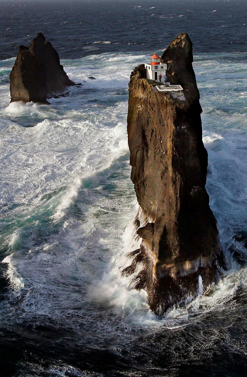
A photograph taken by Morgunblaðið photographer Árni Sæberg of the Þrídrangaviti lighthouse in 2009 has now become viral thanks to Justin Bieber of all people.
Árni Sæberg is photographer for our sister publication Morgunblaðið (and also takes photos for us at Iceland Monitor). The lighthouse, Þrídrangaviti, is located in the Westman Islands and is located around six miles from the shore. It's quite possibly the most isolated lighthouse in the world and is precariously perched on top of a rock pillar with the wild waves of the cold North Atlantic ocean raging below.
Þrídrangar means "three rock pillars" and the lighthouse was built there in 1939. The lighthouse has also been an inspiration to literature, with best-selling thriller novelist Yrsa Sigurðardóttir using it in her novel "Why did you lie?" This is not the first time that Sigurðardóttir draws inspiration from Sæberg's photos. His photos of the deserted farmhouse in Hesteyri in the remote West Fjords became the setting of her spine chilling ghost story, I remember you, which recently was made into an Icelandic film of the same name.
THRIDARANGAR LIGHTHOUSE
A photograph taken by Morgunblaðið photographer Árni Sæberg of the Þrídrangaviti lighthouse in 2009 has now become viral thanks to Justin Bieber of all people.
Árni Sæberg is photographer for our sister publication Morgunblaðið (and also takes photos for us at Iceland Monitor). The lighthouse, Þrídrangaviti, is located in the Westman Islands and is located around six miles from the shore. It's quite possibly the most isolated lighthouse in the world and is precariously perched on top of a rock pillar with the wild waves of the cold North Atlantic ocean raging below.
Þrídrangar means "three rock pillars" and the lighthouse was built there in 1939. The lighthouse has also been an inspiration to literature, with best-selling thriller novelist Yrsa Sigurðardóttir using it in her novel "Why did you lie?" This is not the first time that Sigurðardóttir draws inspiration from Sæberg's photos. His photos of the deserted farmhouse in Hesteyri in the remote West Fjords became the setting of her spine chilling ghost story, I remember you, which recently was made into an Icelandic film of the same name.
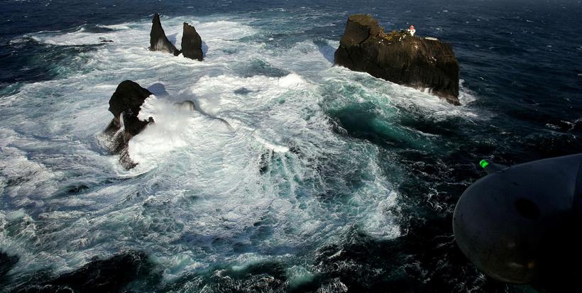
The strong surf below the lighthouse. Photograph/ Árni Sæberg
The strong surf below the lighthouse. Photograph/ Árni Sæberg
Sæberg didn't realise until recently that his photo of the lighthouse had been published all around the world for years until his barber showed him the photo on a German website. The barber's daughter also told him that Justin Bieber had been posting the photo on social media.
Sæberg flew with the national coastguard helicopter, TF LÍF to the take the photo of the lighthouse. It's quite incredible how people actually managed to build this lighthouse, just at WW2 began. In 1939 there were no helicopters so people would have had to sail to the cliff and scale it. In an old article in Morgunblaðið, project director Árni G. Þórarinsson says in an interview, "The first thing we had to to was create a road up to the cliff. We got together of experienced mountaineers, all from the Westman Islands. Then we brought drills, hammers, chains and clamps to secure the chains. Once they got near the top there was no way to get any grip on the rock so one of them got down on his knees, the second stood on his back, and then the third climbed on top of the other two and was able to reach the nib of the cliff above. I cannot even tell you how I was feeling whilst witnessing this incredibly dangerous procedure."
Þrídrangar, the three pillars of rock are in fact four pillars named Stóridrangur, Þúfudrangur, Klofadrangur and the fourth one is nameless. In 1938 a road was constructed to Stóridrangur and the following year the lighthouse was raised. Many years later a helipad was set up on Stóridrangur where helicopters can land.
Morgunblaðið/Árni Sæberg
Morgunblaðið/Árni Sæberg
The national coastguard helicopter flying towards the lighthouse. Photograph/ Árni Sæberg
The national coastguard helicopter flying towards the lighthouse. Photograph/ Árni Sæberg
Location of THRIDARANGAR LIGHTHOUSE
Location of THRIDARANGAR LIGHTHOUSE

