Article

Scary 30m (98.4ft) Wave Off Irelands West Coast Yesterday


by Marine-Pilots.com - published on 29 October 2020 787 -

Screenshot by Christopher Triggs

Wave heights of 50 Ft were already announced, but expectations were exceeded by reality:

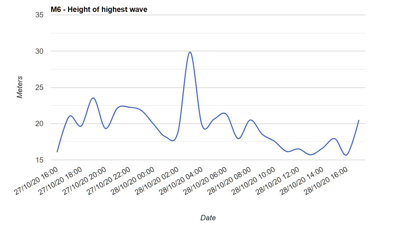
According to information from "The Skipper", a monster wave measuring 30 Mtr – 98.4 Ft was recorded at 03:00 on Oct 28 by the Marine Institute M6 buoy located 200nm West of Ireland.

The wave generated by the tail end of Hurricane Epsilon was one of the highest ever recorded in Irish waters.
Source:
Source: "The Skipper"
Source:
Source: "The Skipper"
M6 Buoy - located 200nm West of Ireland
The network is managed by the Marine Institute in collaboration with Met Éireann and the UK Met Office. The Irish Weather Buoy Network is designed to improve weather forecasts and safety at sea around Ireland. The buoy network provides vital data for weather forecasts, shipping bulletins, gale and swell warnings as well as data for general public information and research.
What's your opinion on this?
Login or register to write comments and join the discussion!
Read more...

Video How to get off the ship with Pilot Siri

published on 31 January 2022

How to get off the ship with Pilot Siri
welcome my ship unlimited bd video channel
#shipunlimitedbd #ship

1

Video Safehaven Marine: Rough weather sea trials of Svitzer Oued Martil.

published on 17 March 2021

Here’s a nice little video of the sea trials of ‘Svitzer Oued Martil’ including some cool on-board 360 camera footage of her going through some pretty big breaking seas during rough weather testing, and some nice foggy day drone footage and trials alongside the Brittany Ferry ‘Armorique’.

0

Video Look at Life - North Atlantic Ocean - Weather Ships - April 1965

published on 18 March 2021

This video is another Look at Life Documentary from Volume 1 - Transport - and features the Weather Adviser - a UK Weather ship from April 1965. In all conditions, special ships maintain a constant scientific watch on the weather.

0

Video IMPA receives the 2022 SAFETY4SEA Initiative Award

by SAFETY4SEA - published on 20 October 2022

International Maritime Pilots' Association (IMPA) received the 2022 SAFETY4SEA Initiative Award for conducting annually its ‘Pilot Ladder Safety Campaign’ with the objective of reporting pilots’ experiences of ladders and boarding equipment to the IMO and the wider shipping community. Other distinguished short-listed nominees of this category were: Inmarsat, International Marine Contractors Association (IMCA), Safetytech Accelerator and Seafarers Hospital Society. We are honored to be...

1

Video Maritime Analytics: The breadth of AIS usage | 10 November 2021

published on 15 November 2021

The growing influence of AIS data and analytics has shed the light on the increasing demand for new, smarter solutions in the maritime domain. During this interactive session, we discuss with AIS industry experts how we can take oceans of data and turn it into streams of actionable intelligence for better decision-making and more efficient and transparent shipping.

0

Article CMPA Launches the National Centre of Expertise on Maritime Pilotage

published on 8 June 2021

The technical body will bring together the extensive technical expertise and professional knowledge of Canada's licensed maritime pilots.

0

Video Ever Forward Freed | What's Going on With Shipping?

published on 18 April 2022

Ever Forward Freed What's Going on With Shipping? April 17, 2022 In this episode, Sal Mercogliano - former merchant mariner and maritime historian at Campbell University - discusses the successful ungrounding of MV Ever Forward from its location outside of Baltimore and its movement to an anchorage off Annapolis. This video will be followed by another with detailed photos and videos once they can be compiled. #EverForward #Cheasapeake #Evergreen #container #containership #logistics...

0

Article GPS interference and jamming on the increase

published on 2 October 2020

Ships have reported an increasing number of cases of significant GPS interference and jamming in recent months. The geographic areas with more than one reported incident include the eastern and central Mediterranean Sea, the Persian Gulf, and multiple Chinese ports.

1

Video PILOT BOAT HAYASUI

published on 24 May 2021

#船、#SHIP、#SEA、#海、#JAPAN、#内航船、#外航船、#船員さんのお仕事、#海技士、#航海士、#PILOT BOAT HAYASUI、#関崎パイロットステーション

0

Article PFMBlue installed on pilot vessel in one of the world most remote ports.

published on 13 June 2022

Lyttelton Port Company Limited (LPC) are the operators of the largest Port in the South Island of New Zealand, have chosenPFMBlue´s GP16B to be installed.

0