photos, graphics and article by Capt. Gunter Schütze
What happened?
MV "Shahraz" and MV "Samudra Sakti I" had run aground to the shallow Batu Berhanti in the Indonesian territorial waters within 6 minutes, which is surveyed with minimum water depths of 8.3 m in the northern part and up to 0.5 m in the southern part . It is located south of TSS Singapore Strait’s eastbound traffic lane.
A chain of events which must be described as extra ordinary rarity. Which naturally raises questions about how may this happen.
The ships involved:
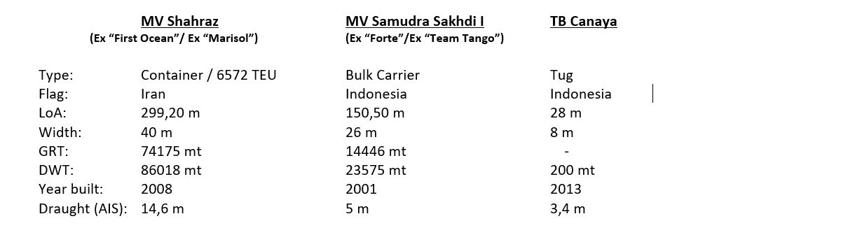
MV "Shahraz" was in transit from Port Klang to Yanshan
MV "Samutra Sakhdi I" was in transit from Belawan / Sumatra to Bayah / Java?, At least according to AIS data, which in turn raises questions, because Bayah is located on the SW coast of Java.
TB Canaya reported in AIS, ETA: Buatan / Sumatra, Indonesia on 13th May 2020, 17:00 LT.
First superficial look
Before I delve deeper into these events, I would like point out that all referenced times are based on the local time of Singapore Strait.
In the past few days, I have intensively analyzed the terrestrial AIS-data of the ships listed. I send ahead that there on the two ships are some nautical and navigational contradictive events, which did lead to run aground and that do not provide a logical explanation about, but which were fundamental to the occurrence of these disasters.
Weather conditions
There were no weather-related influences that would have affected events so early in the morning that they would have been decisive for the accidents. As always it must be pointed out that the wind influences in this region are negligible, so they have no serious effects on waves and swell.
Impairments caused by weather events, particularly reduced visibility due to heavy rain, which can also have a significant impact on radar navigation during strong thunderstorms, are only temporary. Nothing is known about such events at the time.
Current conditions
The Singapore Strait is known to have areas with very strong currents, up to 5-6 knots depending on the tide.
North of the shallows of Batu Berhanti, currents of up to 5.5 kt are by no means unusual, and in the precaution area / traffic crossing zone as access to the Keppel harbor, currents of 2.5 to 3 kn are not uncommon.
The tidal data for Singapore given for 11.05.2020:
at 01:10 LT (2.8 m) and 14:32 LT (2.5 m) high water and for 07:56 LT (-0.1 m) and 20:01 LT (1.2 m) low water.
At the time of the two events around 02:15 LT, there was running off water, the current strengths were still low, since there was only 1 hour between the high water ( calm water) and the event. (May 12, 2020, 1:45, 2.8 m). So there is not a strong tidal current influence while the time of the accidents.
AIS tracking in Singapore Strait
In the Singapore Strait, both terrestrial AIS tracking method and satellite tracking method are used. In my analysis, I am referring to the data available for the terrestrial AIS tracking process.
Reporting system STRAITREP in Singapore Strait
Singapore Strait is divided into Sectors 7, 8 and 9 of the STRAITREP system (West / Central / East sector). It is monitored by Singapore VTS. The reports are made according to defined reporting procedure shortly before leaving the previous and shortly before entering the next sector. This means that aboard ships must be the constantly readiness for calls on assigned VHF channels (Sector 7 –Ch 73 / Sector 8 - Ch 14 / Sector 9 - Ch 10) must be warranted. I refer to the “PORT MARINE CIRCULAR NO. 65 OF 1998 ”from October 20, 1998 by MPA Singapore for further details.
In the past, VTS Singapore has proven to be a competent, reliable institution in traffic control and with its implemented warning system for nautical and collision risks.
This also makes it clear that VTS Singapore always points out dangerous situations if they are identified. From this point of view, I am convinced that both MV "Shahraz" and MV "Samudra Sakti I" have been warned of the danger to run aground with their used courses.
Shoals of the Singapore Strait on the eastbound traffic lanes
There are several shallows to be noted on the eastbound Traffic Lane in TSS Singapore.
Sector 8:
Tonkon KCL - 2 m shallow characterized by cardinal buoy South, port side traffic lane
Helen Mar Reef - dry falling, starboard side, Cardinal North, equipped with Racon
Karang Banteng - dry falling, starboard side, Cardinal North, equipped with Racon
Batu Berhanti - dry falling, starboard side, Cardinal East, equipped with Racon
Sector 9:
Karang Selatan, 1.8 m shallow, starboard side, SW-ly of Pedra Branca, not marked with bouys or beacons
Pedra Branca (Horsburgh LH), rock, dry falling, starboard side,
All of the shallows and reefs mentioned are located outside the traffic lane. So if you are sailing within the traffic lane there is no way to hit these shoals.
Singapore Strait - Density of maritime traffic
Singapore Strait is the busiest shipping lane in the world. This is also reflected in the sometimes immense volume of traffic density and crossing traffic, eastbound from the terminals of Tanjung Pelepas, Pasir Panjang and Keppel, as well as the crossing traffic from Indonesia. In addition, there are numerous anchorages with the huge amount of vessels at anchor, which occasionally cause confusion. In addition to conventional maritime traffic, there is also the individual traffic by small boats, fishermen and towed convoys, which unfortunately are not particularly precise with the COLREG rule 10 behavior in TSS .
Singapore Strait highly recommended bridge watch system
From the factors mentioned so far, it goes without saying that increased attention on the bridge is essential during the passage through the Singapore Strait. For this reason, the passage is disputed as river passage from a safety perspective, which means
-The bridge has at to be manned with captain, an officer on watch, helmsman and an additional lookout. If necessary, the personnel on the bridge must be reinforced
-I strongly recommend that the captain take command during the passage through the Singapore Strait. This does not release the officer on watch from his duties as an officer on watch
-The availability of all required VHF channels must be ensured
-Radar systems must be used in different distance measuring ranges
-CAUTION: AIS is an information system and not a system for collision prevention!
-All radar contacts must be tracked and visually observed and checked for collision risks
-Position determinations have to be carried out primarily with the usual methods of radar navigation and visually and GPS is to be used as a backup
-Position determinations must be carried out at short intervals (6 or 12 minutes) and must be documented in the bell book / manoeuver diary.
-The fore ship has to be manned, both anchors must be immediately ready for dropping.
-The main engine control is in the maneuver mode to be available for quick maneuvers.
-The ECR has to be staffed with CE or 2nd Eng. so that in the event of technical engine problems, it is possible to switch immediately to other main engine control modes.
-The principles of consistently effective and efficient BRM / BTM are to be implemented in order to ensure smooth, safe bridge operation, safe navigation and ship safety under all circumstances.
I want refer at
1.STCW 95, including Manila 2010, Chapter VIII and Section B-VIII / 1 and B-VIII /2
2.SOLAS 74 Chapter V - Safety of Navigation, especially Regulation 34 “Safe navigation and avoidance of dangerous situations” and Regulation 34-1 “Masters discretion”
3.RESOLUTION A.893 (21) GUIDELINES FOR VOYAGE PLANNING (adopted on November 25, 1999)
4.Company SMS and vessel SMS like Bridge Operation Manual (BOM) based on ISM Code.
This brief introduction to the bridge and ships organization for areas with a high density of maritime traffic and very special nautical challenges, which, due to their spatial limitations, limit the scope of action of the ship's command and require increased attention, is intended as a reminder. I will go into it a bit more in the course of analyzing the events in Singapore Strait on the night of May 10th to May 11th, 2020.
How I practice it on vessels under my command?
As a captain, I basically handled it in such a way that I always appeared personally early before the vessel arrived such traffic spots to get an update about the situation. Mostly I did keep the ship's command under the control of the officer on watch as duty officer. To give him the opportunity to get new extended experiences for his future roles. I acted as supervisor and assistant to support the officer on the watch. Depends on the situation found or clearly visible uncertainty on the part of the officer on watch, I took over the command of the ship. The assumption of the ship's command was clearly announced to the bridge personnel and recorded in the log book. This has nothing to do with the fact that I do not trust my bridge watch officers, but rather from the fact that I, as the captain, have sole responsibility and have to live up to it. For this purpose, the officers on watch were always made very clear that they are in no way relieved of their duties as officers of the watch, but have to be fully implemented.
Basically, all voyage plans and thus the local peculiarities were discussed with all bridge officers on watch in briefings, so that each officer of the watch had the same level of knowledge about tide conditions, meteorological and nautical features, danger areas, communication channels and could contribute.
AIS - analysis of the events
Since May 10, 2020, 23:50 LT, both ships have been recorded in terrestrial AIS in TSS Sector 7, in the eastern part of Selat Duriam at the transition to the Philip Channel.
"Shahraz" followed with a draught of 14,6 m, reported by AIS, with 12 kt of the eastern traffic lane outside the deep water way. A sign that the ship was well laden. The logical consequence of this, of course, means that a longer stop distance is also required in an emergency in the case of a heavy ship due to the moving mass.
"Samudra Sakhdi I" sailed with a draft of 5.4 meters, reported by AIS which indicated that the vessel was underway in ballast, easterly outside of the traffic lane. On May 11th, 2020, at 00:35 LT, Samudra entered the eastern TSS Lane approx. 1 nm south of Helen Mar Reefes and followed the TSS lane
MV "Shahraz"
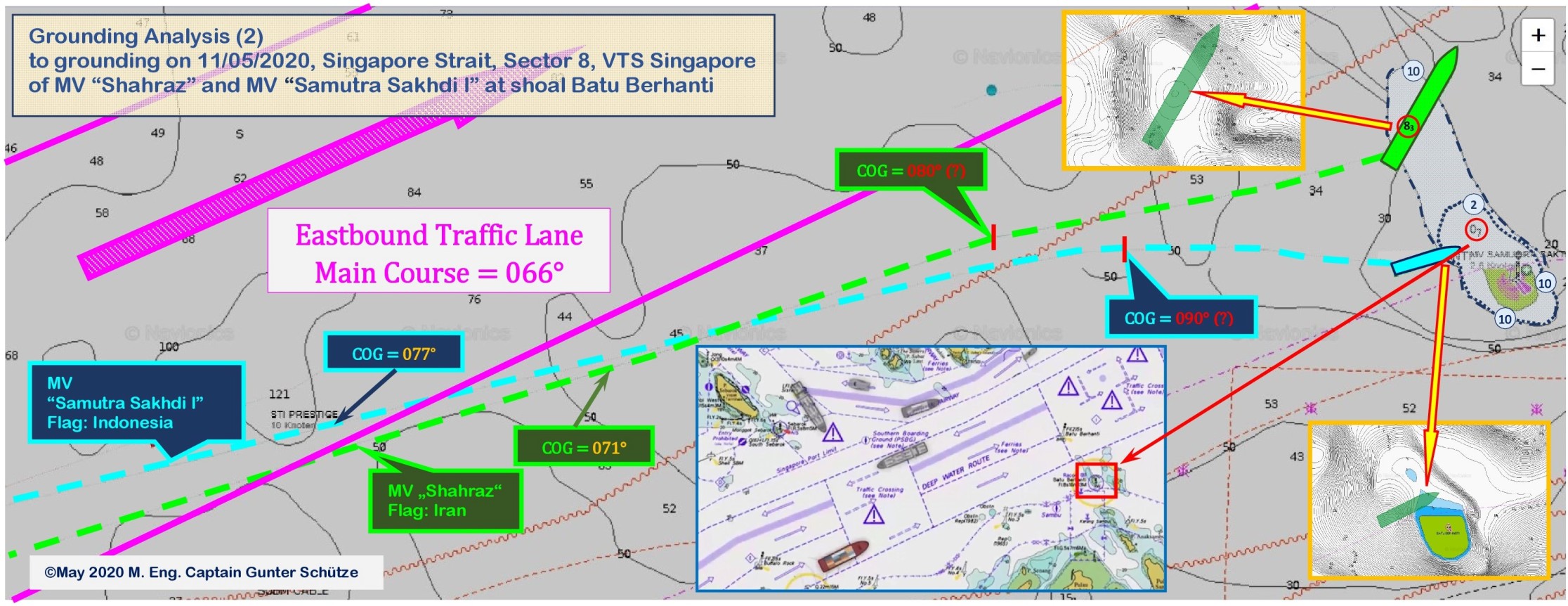
It became interesting on 11.05.2020, 01:56 LT when "Shahraz" passed the western boundary of the precaution area and traffic cross zone for the access to the Pasir Panjang Container Terminal. Instead of following the main course of the TSS Lane of 066°, the "Shahraz" altered her course to 071°, maintained him continuously, as can be seen from the lower graphic of the AIS-Track reconstruction by MV "Shahraz". It is possible to speculate about the reasons for this change in course, but there is no recognizable navigational need or collision avoidance need.

We come to a graphic that could perhaps explain the course alteration of the "Shahraz". But it doesn't seems plausible to me. For several reasons. The following graphic may be a hint that the outsider does not see at first glance.
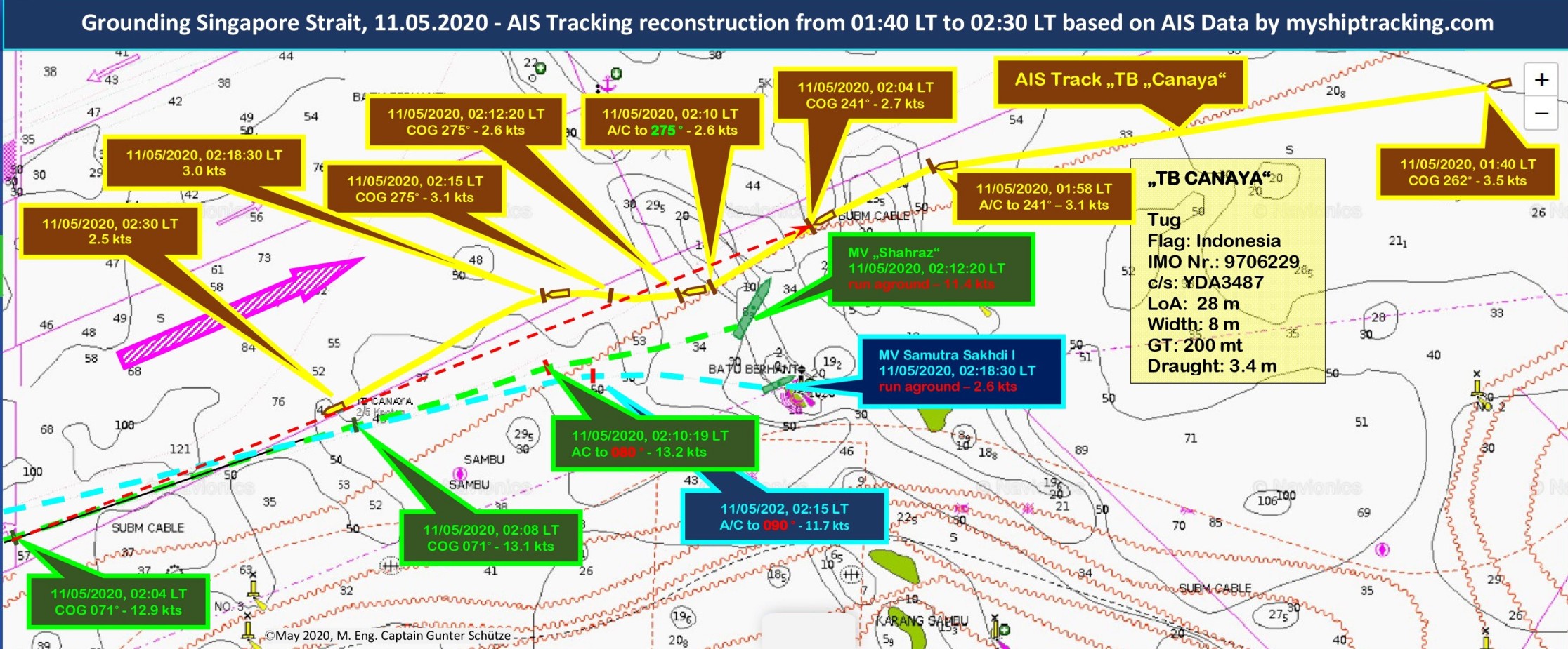
In the graphic above, the course of the AIS route of the tug “TB Canaya” is reconstructed, which travels from the east southerly of TSS Lane, i.e. clearly outside the TSS, with a SW-directed course. Additional it will be shown the AIS routes of the two vessels which are involved in the accidents. The low speed of TB "Canaya" of 3.5 kt suggests that it is a tow convoy typical of the Singapore Strait. It can be clearly seen that "TB Canaya" always strives to stay south and outside of the TSS.
The following graphic gives an overview of bearings and distances between MV "Shahraz and TB" Canaya "from the time of the course alteration of " Shahraz" to course 071°.
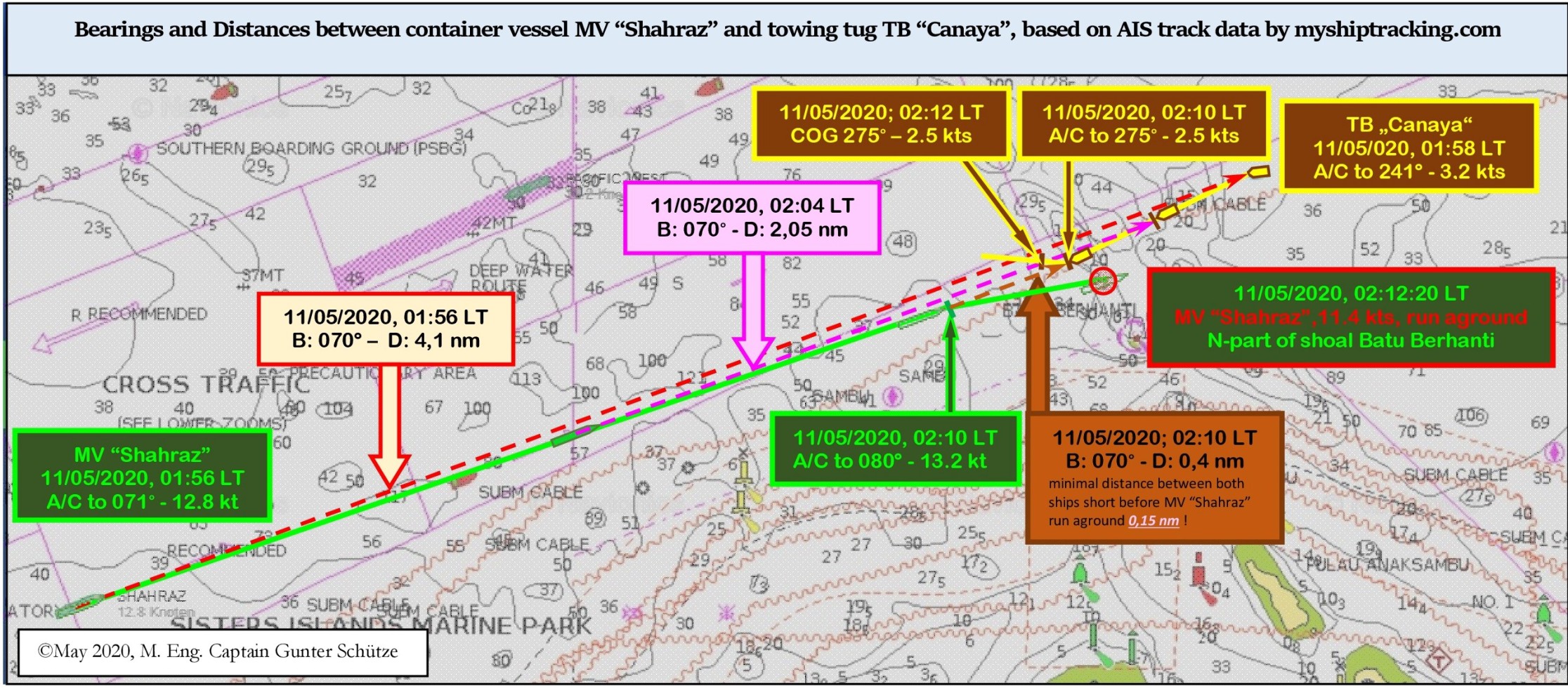
From this graphic it can be seen that the course alteration of the “Shahraz” was the starting point for all further executed actions of the involved vessels. The course alteration only allows one conclusion that the watch officer on the bridge of MV "Shahraz" was completely wrong in his conclusions and TB “Canaya” was identified as a vehicle became which had the intention to cross the TSS. This seems it did lead to the intention to pass TB "Canaya" behind her stern. It is not known whether the bridge officer did verify TB "Canaya" as a tow convoy. There is no other explanation for this course alteration under consideration of all moving targets in the area at this time.
And it seems that the officer on watch was not at all aware of the danger of the shallow ahead, which in turn is a clear indication that the nautical danger zone did not seems to have been known. This casts long shadows on the quality of voyage and route planning and the execution of the duty on the bridge.
In a closer look and weightening all possible variants by an experienced navigator, there is absolutely no reason to initiate a course alteration towards starboard. What for? It would have been more advisable to orientate yourself more towards the center of the traffic lane, i.e. either maintain the course of 066° or slight further to port side order to keep clear of the southern edge of the lane. Because the northern part of the Batu Berhanti is extend with NW-ly direction inside eastbound lane with a 14.4 m water depth on the south edge.
This should be logical consequence with a draft of 14.6 m, since it is reasonable. I assume that the officer on watch was also not aware of the tide conditions.
Under an intensive radar observation, it would have been noticed that 01:58 LT, i.e. only 2 minutes after the course alteration from MV "Shahraz ”, TB“ Canaya ”significantly changed the course to portside by 20 degrees to 241°.
This course alteration by TB "Canaya" caused that the intended effect of the starboard course alteration of “Shahraz” was nullified and a classical situation with a constant compass bearing of an approaching vessel without changes had been created.
If the vectors of relative speed between "Shahraz" and TB "Canaya" with 2,7 cbl/ minute be taken in relation to distance of 4,1 nm, a TCPA of 15 minutes will be calculated. Enough time for an intensive new situation analysis and the cognition would be clear identify that TB "Canaya" would not enter the TSS, so there was no reason for the course to be altered prematurely. And it would have been noticed that a Racon, was in approx. 3 nm ahead, which correspondents with the shallow of Batu Berhanti, equipped with a cardinal E - beacon. If a view would be taken to sea chart and a visible control had been done out of the bridge window it had been well noticed.
And on the other a well adjusted UKC-alarm in ECDIS and in the echo sounder would early alert about the dropping minimum keel clearance, as an additional safety tool.
The logic consequence would be to go back to the lane and follow her in the center. The time window did allow such revision of the former decision. But....
The conclusions that can be derived from this for me can only come to the following questions:
-Why was the radar observation for TB “Canaya” not continued and analyzed continuously?
-Which radar systems (3 +10 cm radar or only 3 cm or only 10 cm radar) , which radar mode and which distance ranges were used?
-Which UKC was used as an additional alarm tool for the passage through the Singapore Strait? Has the UKC been taken into account at all?
-How was the bridge manned? (2nd officer and helmsman and no one else?) And if that was the manning of the bridge, when was the captain called to the bridge?
-In what steering mode was the vessel controled? (Track mode / Heading mode / Autopilot or manual)
What arrangements of lights did TB “Canaya” use as a tow or push convoy? COLREG rule 3(g)/ Rule 23(a)/ Rule 24)?
-Is there a possibility that the watch officer did use AIS as a collision-prevention alternative to assess the situation and thus neglecting radar observation? It would not be the first case.
-Have all required VHF channels been monitored continuously? Why were VTS Singapore calls and warnings ignored?
-Where was the captain when he wasn't on the bridge? And why wasn't he on the bridge. It is very likely that the officer on watch was the only officer on the bridge.
-Was there an extra lookout next to the helmsman? If not, why not?
-Was the fore ship manned and the anchors ready to drop immediately?
-What measures were taken by the ship's command to ensure an effective and above all safe bridge organization based on efficient BRM / BTM for the passage through the Singapore Strait after leaving Port Klang?
-Could it be that the watch officer was completely overcharged with the situation, in lack of missing experience so that it posed an enormous safety risk?
It becomes clear that "Shahraz" continued to hold on to its course of 071 ° and its speed of 12-13 kt continuously, for unknown reason, which would continue abruptly ending if this course continued on the shallow Batu Berhanti.
At 02:10 LT, both ships initiated a course alteration to starboard as an evasive maneuver. TB "Canaya" altered course from 240 ° to 275 °, which led to that she did enter the to east directed TSS Lane. She followed COLREG rules 7 (a) and 7 (d), (ii), 17 (a), (ii), 17 (b), 17 (c) as a tow convoy.
"Shahraz" altered course from 071 ° to 080 ° without reducing speed [COLREG Rule 6 (a) (iii), (vi), 6 (b) (iv)] which can only have one consequence. With 14,6 m draft without speed reduction Shahraz run aground on the northern part of the shallow Batu Berhanti with a reported water depth of 8.30 m, at 11.4 kt speed.
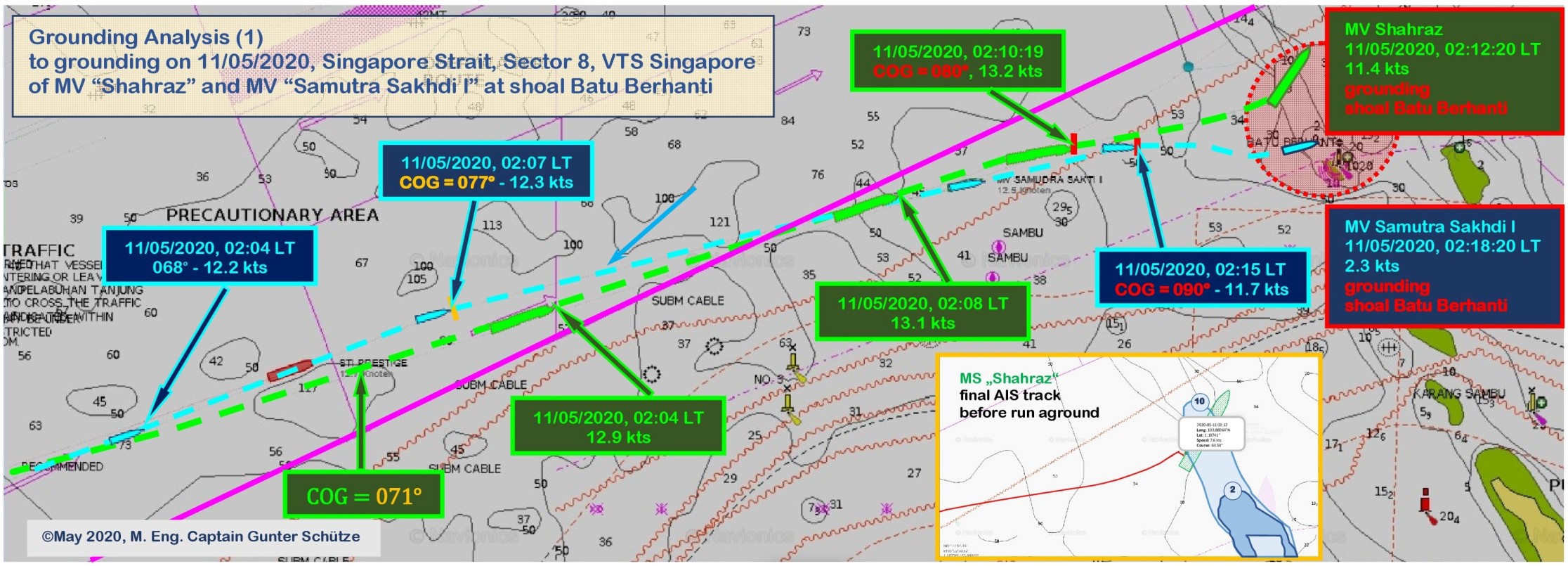
On May 11th, 2020, 02:12:20 LT, the journey of the “Shahraz” to Yanshan was abruptly stopped by the shallow Batu Berhanti.
MV "Samudra Sakti I"
From the AIS reconstructions it follows that MV "Samudra Sakti I" behaved inconspicuously until May 11th, 2020, 02:07 LT. She followed the lane courses of the east directed TSS traffic lane with 066° to 068 ° with a speed of 11-12 kt.
Around 02:07 LT "Samudra Sakti I" initiated a course alteration towards starboard side on position 01° 10.7 'N, 103° 50.85' E, to 077°. Again, the question from a navigational point of view, what purpose this change of course should serve. The traffic situation had been cleared by the previous course alteration to port side, at course 241°, by TB "Canaya" so it was no longer a problem for "Samudra Sakti I". So it could not have been the cause of the course alteration.
There is no recognizable need for this course alteration.
Apart from the possible intention to cross the northern part of the shallow Batu Berhanti (reported with 8.3 m minimum depth), which would be possible at a 5.4 m draft.
But without taking in account of the appeared SWAT effects to occur at speed of 10-12 kt. Which should have a significant disadvantageous effect on the under keel clearance, because the difference between the minimum water depth of 8.3 m and 5.4 m draft are result in just 2.9 m under keel clearance. Without SWAT and tide effect.
Taking into account the high tide for 11.05.2020, 01:10 LT with 2.8 m high water, it can be roughly estimated that with an hourly decrease in water level of approx. 43 cm at the time 02:15 LT the high water approx. 2.30 m would be. That means that a under keel clearance of approx. 5.2 m, without taking SWAT effects, would available be. If the speed would be adjusted accordingly, it would not have been a problem for “Samudra Sakti I” to cross the northern part of the shallow Batu Berhanti.
But which conscientious navigator, who sets safety against hurry as the measure of his action, comes, in my view, to such admittedly questionable decision if it is much more safe to follow the TSS traffic lane?
When it was recognized on "Samudra Sakti I" that "Shahraz" did run aground in front of her, there was at 02:15 LT only the alternative at to alter course to starboard to avoid a collision. But instead of consistently using a hard starboard maneuvers, as a last-minute maneuver, to initiate a 180° turning circle in order to go on the opposite course and thus get into safe water and avoid the ground contact, an inexplicably half-hearted maneuver with a course alteration to starboard side on course 090° was executed, which inevitably had to lead to the fact that in the southern part of Batu Berhanti, with reported minimum Water depth of 0.5 m was run aground. The decision to consistently take the speed out of the ship with the appropriate engine maneuvers resulted in a low speed of 2.3 to 2.6 kt (AIS data). This did at least ensured that the stern section of the under water hull did remain in the open water and that the ship's propellers were not damaged, which was advantageous for later trials at own salvaging with own propulsion from the shallow water.
Also in case of MV „Samudra Sakti 1“ the same questions are required to ask, how I had in case of MV "Shahraz", because the duplicity of the events is surprisingly and amazing all together.
The evaluation of my analysis
I emphasize again that this analysis is based on the available AIS data and from the perspective of an experienced navigator. These assumptions result as causality (causality is the relationship between cause and effect. It relates to the sequence of events and states that are related to each other) of the analyzed facts. They do not claim to be complete. This she can't fulfill.
This requires the VDR data of the ships, the voice records from VTS Singapore and of course the witness surveys on board.
This analysis doesn't has not the aim to substitute investigations by flag state authorities, port state authorities, shipping companies, insurance companies. This would be pretentious.
It is a trial of a first analysis, from a nautical and ship guidance point of view. Which may can provide an explanation of the events, but it isn't a must does to explain how these absolutely unusual events came about through a remarkable chain of errors. However, I assume that it is quite a on facts and many years seagoing experience based analysis, with the required background knowledge. What I think comes relative close to the reality.
Well-prepared simulations are certainly a good way to reconstruct the events. However, quick shots don't help. The video sequences (https://youtu.be/QAA77cSX8-Q) of simulations (Made Smart Group Amsterdam) that I have seen so far on these events in "You tube" have a serious error. They assume that "Samudra Sakti I" ran aground at a speed of 10-11 kt. I can rule that out with absolute certainty, 2.3 to 2.6 kt, maximum 3 kt was the run-up speed, this is confirmed by the analysis of the AIS data.
Answers to all the open question under usage of all exisiting evidence material will be only given with an official investigation by flag state and port state authorities, by the operational management from V-Ships, by the maritime insurances. It would be very helpful to publish the final investigation report for the wide maritime community to draw the right conclusions for the future to avoid such further events.
Media reporting
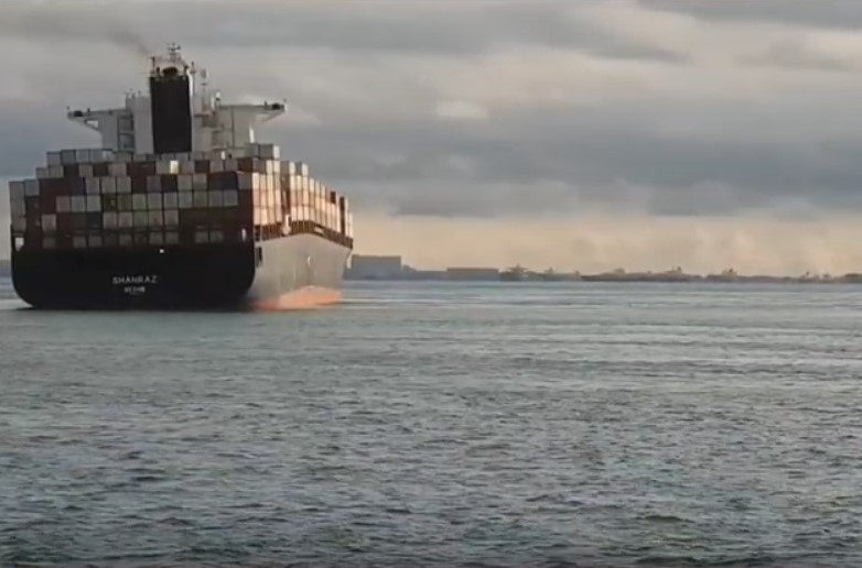
In the first media announcements there was talk of a collision which led that vessels run aground. After looking at the photographic shots of MV "Shahraz" that were later delivered, it was clear to me that the damage to the ship was not due to a collision. A COLLISION can be ruled out because collision damage results in a completely different damage pattern.
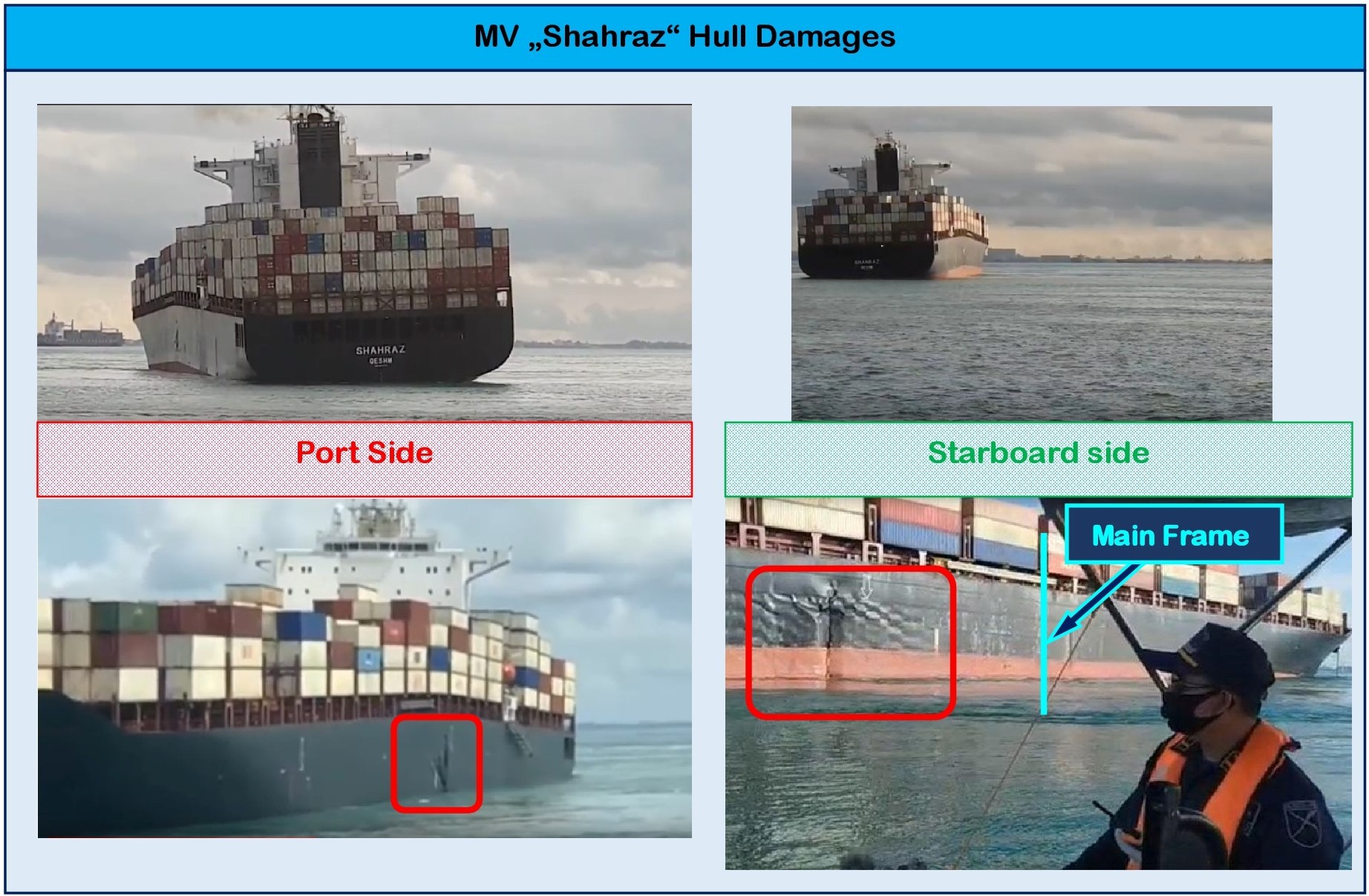
The visible damage was significant damage caused by an extreme overstressed ship hull structure by extreme forces and even allowed the conclusion that the keel of the ship was extremely bent, if not broken. It is probably a happy coincidence that the damage documented in the pictures so far has been limited to areas of empty ballast tanks and environmental oil pollution by damaged heavy fuel oil tanks could be avoided.
As a comparison, reference should only be made to the pictures of MSC "Napoli", MSC Reina ", MOL" Comfort ", which documented the structural problems of the hull or were caused by ground touches that led to the ships breaking apart.
Initial Damage Analysis
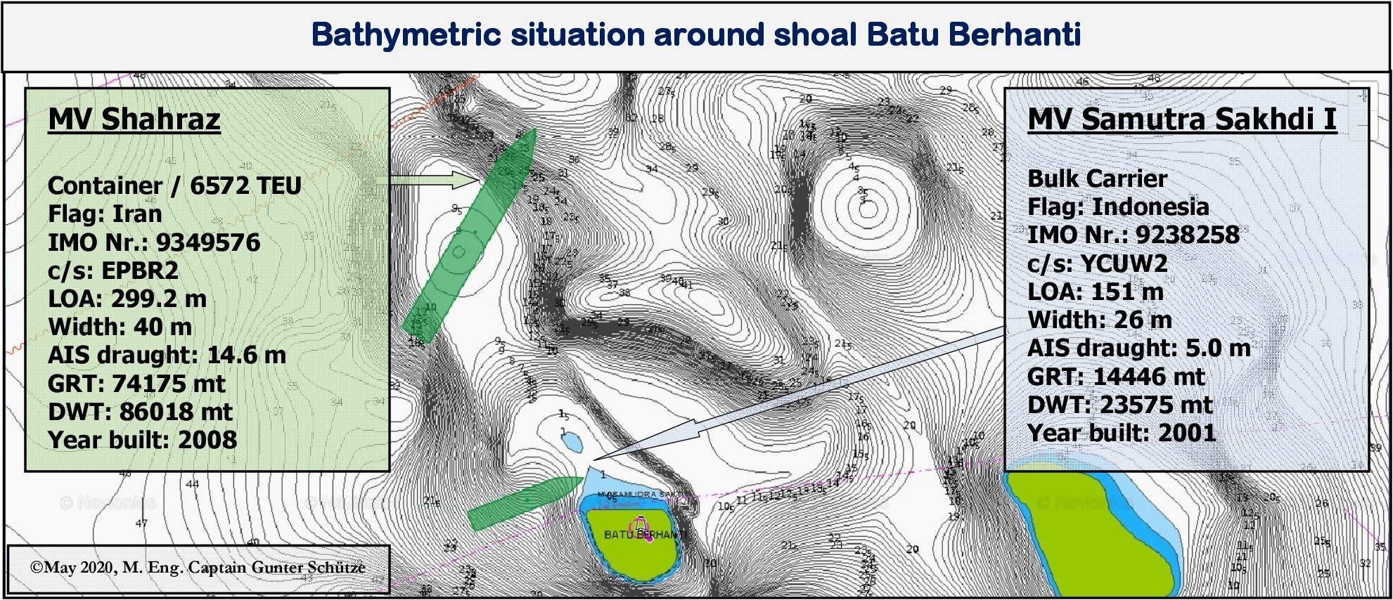
The bathymetric graphic above shows how the two ships did run aground and how they are positioned on the shallows. This allows first conclusions to be drawn about the possible damage status of the ships. Which will be discussed in more detail below.
MV Shahraz
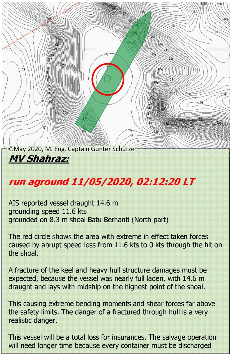
From the available facts and the fact that MV "Shahraz" with a draft of 14.6 m run aground with a speed of 11,4 kts on underwater obstacle in a water depth of 8.3 m, even the greatest layperson should be aware, about serious consequences for the ship. Because "Shahraz" was well laden, did additional large masses reinforced the effects.
The abrupt stopping of the ship, from 11.4 kt to 0 kt on an underwater obstacle, caused an enormous strain on the ship's hull structure far beyond the constructively calculated forces. The laws of physics have shown their full effect here. Since the vessel lies on the highest point of the shoal with position approx amidships, as be seen from the graphic on the left, extreme bending moments and shear forces occur which are far above the permissible values. The result is that the ship structure are literally torn apart at the points of the most powerful forces.
Especially since the tremendously acting forces severely damaged the ship's keel at the point of touch and thus cancel its stabilizing effect, which inevitably can lead to the ship breaking apart. It is thanks to the happy fact that the ship is lying on the sea floor that it has not yet broken apart, because the container weights in the holds and on deck are massively pushing the fore and aft part of the ship down. This leads to extreme hogging on the support surface (roughly midship) of the underwater ship, so that additional extreme stress is exerted on the hull structure, which can force the ship to break apart.
From an insurance perspective, the ship is a total loss.
A salvage will take a long time, because the containers have to be unloaded individually, fuels and operating fluids have to be pumped out in order to lighten the ship and to prevent massive environmental damage caused by oil contamination during a salvage. It may even have to be separated to be salvaged in two parts.
An expensive insurance loss.
MV "Samudra Sakti I "
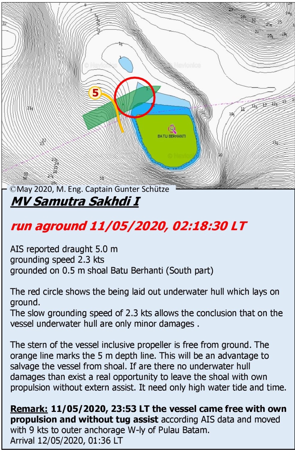
The situation looks much more comfortable for "Samudra Sakti I". Due to the low speed between 2.3 - 2.6 kt, probably maximal 3 kts when run aground, it can be assumed that the damage to the underwater ship is only minor.
The position of the ship, in the bathymetric representation on the left in the picture, on the shallow ground, clearly contradicts the simulation assumption that the “Samudra Sakti I” ran up to the shallow ground with 10-11 kt. Than she would lay complete high and dry on the dry falling obstacle. Because the ballast condition with trim to aft will support a fast running onto rock/ sand bank that the whole under water hull would be on the rocks/sand bank and the propeller become with a high probability damaged.
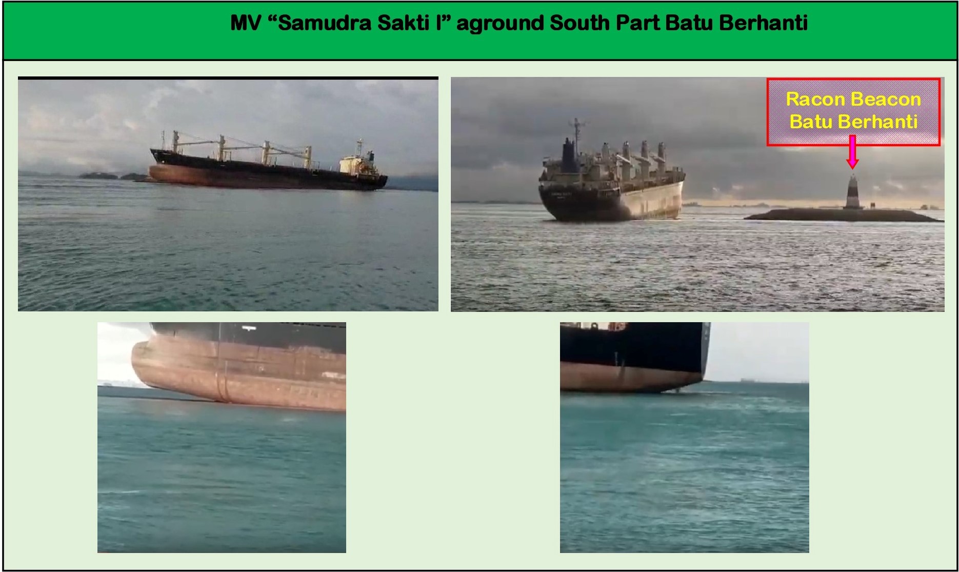
he big advantage is that the entire aft underwater ship is exposed and the ship was in ballast, as a relatively light ship.
So, after a detailed examination of the position of the ship on the shallow, there is the possibility, provided that damage can be excluded, that the ship pulls from the shallow with its own propulsion.
With up coming water of the tidal flood on May 12th, 2020, at 01:45 LT with a height of 2.80 m, this is a serious and promising alternative.
I would try it. If there it would have success to come free, than I would sail to an anchorage in the area. Further investigations about damages by diver underwater survey in close collaboration with port state authorities, company, flag state authority, classification society, insurance, are urgent required.
Supplement
In the late evening hours of May 11th, 2020 I was able to ascertain 23:35 LT that “Samudra Sakti I” actually freed itself from its position on its own and sailed to the Batu Ampar Anchorage with speed of 9 kt and anchored there . A sign that the ship is probably really only slightly damaged.
Concluding Assessment
The terrestrial AIS data based on Myshiptracking.com only allow an initial careful analysis.
In order to be able to achieve much more precise results there, it is necessary to use all resources for ship-internal data acquisition and records (VDR/ ECDIS records/ Alarm panel monitoring and others more) and external data acquisition and records by VTS Singapore, and of course the interviews of the crew. I don't have these options.
In this respect it is not possible for me to make statements
-how the bridges were organized
-who was responsible for the ship's command,
-to execution of the internal bridge watch system,
-about manning on the bridge,
-to voyage and route planning,
-for position determination and position monitoring
-to compliance with BRM / BTM
-internal communications on the bridges
-to the level of maritime English of the bridge officers
-to the level of VHF Channel monitoring and VHF radio communication
Which of course affects my analysis. However, logical correlations can be determined from the AIS data, which from the practical point of view of the experienced navigator inevitably may lead to different interpretations, than that of the watch officer from MV "Shahraz" and MV "Samudra Sakti I".
The decisions of both ships to alter their course towards starboard and the associated leaving the traffic lane, on the basis with the argument of an initiated evasive maneuver towards TB "Canaya" is in no way comprehending to me.
Neither navigational reasons nor the argument in COLREG make sense from my point of view if I point out that both were in the traffic lane. It is correct that COLREG Rule 10 doesn't override the valid collision avoidance rules in COLREG. This rules have to be applied. In this case, however, a well-founded radar and visual observation would have been able to determine, that did not result in a collision situation, based on e.g. a fixed guard sector or a fixed TCPA of 12 minutes as guideline .
It were the in my understanding overhasty course alterations of both vessels to starboard side that created the critical situations and up coming the dangers. And this without any need. Especially I did win the impression, that the nautical hazard Batu Berhanti either was unknown to both bridge teams or was completely underestimated. This opens up further questions, the deeper consideration of which would go beyond the scope of this analysis. However, it can be seen from the AIS data that TB "Canaya" never posed a real collision risk since she was always southerly and therefore OUTSIDE of the traffic lane on a SW-ly course, i.e. parallel to TSS traffic lane on the opposite course.
If MV "Shahraz" and MV "Samudra Sakti I" did continue their courses 066° to follow the TSS traffic lane or would have slight altered their course a bit to port side, to the centerline of the traffic lane, had been all subsequent tragedies not occurred.
These accidents were avoidable and this must also so clear formulated. Why they occurred is up to the official investigation commission, which can investigate much deeper than I can.
An interesting addendum:
I had pointed out in the paragraph "STRAITREP" that VTS Singapore addresses the ships directly when it detects dangerous situations and warns of the detected dangers. A press release issued by the MPA Singapore on May 11, 2020 confirmed that both ships had been warned of the danger of running aground. The press release states:
"Prior to the incident, both vessels were warned by MPA’s Port Operations Control Center (POCC) of the risk of grounding." and further: "But both vessels apparently ignored the warnings."
This statement confirms my finding that VTS Singapore is always transmitting warning if dangers are detected. And it confirms assumption about an insufficent or no carried out VHF radio monitoring and probably problems with the application of the English language
Nevertheless, I believe that in my short treatise on the causes of the accidents, I was able to clearly work out why these accidents occurred. The result of the investigation will certainly look at the events in more detail. In the basic statement that I represent, there will be no groundbreaking differences to an official investigation result. I'm pretty sure about it.
With this in mind, I am eagerly awaiting the official investigation results, in the hope that they will also be made available to the maritime community.
What happened?
MV "Shahraz" and MV "Samudra Sakti I" had run aground to the shallow Batu Berhanti in the Indonesian territorial waters within 6 minutes, which is surveyed with minimum water depths of 8.3 m in the northern part and up to 0.5 m in the southern part . It is located south of TSS Singapore Strait’s eastbound traffic lane.
A chain of events which must be described as extra ordinary rarity. Which naturally raises questions about how may this happen.
The ships involved:
MV "Shahraz" was in transit from Port Klang to Yanshan
MV "Samutra Sakhdi I" was in transit from Belawan / Sumatra to Bayah / Java?, At least according to AIS data, which in turn raises questions, because Bayah is located on the SW coast of Java.
TB Canaya reported in AIS, ETA: Buatan / Sumatra, Indonesia on 13th May 2020, 17:00 LT.
First superficial look
Before I delve deeper into these events, I would like point out that all referenced times are based on the local time of Singapore Strait.
In the past few days, I have intensively analyzed the terrestrial AIS-data of the ships listed. I send ahead that there on the two ships are some nautical and navigational contradictive events, which did lead to run aground and that do not provide a logical explanation about, but which were fundamental to the occurrence of these disasters.
Weather conditions
There were no weather-related influences that would have affected events so early in the morning that they would have been decisive for the accidents. As always it must be pointed out that the wind influences in this region are negligible, so they have no serious effects on waves and swell.
Impairments caused by weather events, particularly reduced visibility due to heavy rain, which can also have a significant impact on radar navigation during strong thunderstorms, are only temporary. Nothing is known about such events at the time.
Current conditions
The Singapore Strait is known to have areas with very strong currents, up to 5-6 knots depending on the tide.
North of the shallows of Batu Berhanti, currents of up to 5.5 kt are by no means unusual, and in the precaution area / traffic crossing zone as access to the Keppel harbor, currents of 2.5 to 3 kn are not uncommon.
The tidal data for Singapore given for 11.05.2020:
at 01:10 LT (2.8 m) and 14:32 LT (2.5 m) high water and for 07:56 LT (-0.1 m) and 20:01 LT (1.2 m) low water.
At the time of the two events around 02:15 LT, there was running off water, the current strengths were still low, since there was only 1 hour between the high water ( calm water) and the event. (May 12, 2020, 1:45, 2.8 m). So there is not a strong tidal current influence while the time of the accidents.
AIS tracking in Singapore Strait
In the Singapore Strait, both terrestrial AIS tracking method and satellite tracking method are used. In my analysis, I am referring to the data available for the terrestrial AIS tracking process.
Reporting system STRAITREP in Singapore Strait
Singapore Strait is divided into Sectors 7, 8 and 9 of the STRAITREP system (West / Central / East sector). It is monitored by Singapore VTS. The reports are made according to defined reporting procedure shortly before leaving the previous and shortly before entering the next sector. This means that aboard ships must be the constantly readiness for calls on assigned VHF channels (Sector 7 –Ch 73 / Sector 8 - Ch 14 / Sector 9 - Ch 10) must be warranted. I refer to the “PORT MARINE CIRCULAR NO. 65 OF 1998 ”from October 20, 1998 by MPA Singapore for further details.
In the past, VTS Singapore has proven to be a competent, reliable institution in traffic control and with its implemented warning system for nautical and collision risks.
This also makes it clear that VTS Singapore always points out dangerous situations if they are identified. From this point of view, I am convinced that both MV "Shahraz" and MV "Samudra Sakti I" have been warned of the danger to run aground with their used courses.
Shoals of the Singapore Strait on the eastbound traffic lanes
There are several shallows to be noted on the eastbound Traffic Lane in TSS Singapore.
Sector 8:
Tonkon KCL - 2 m shallow characterized by cardinal buoy South, port side traffic lane
Helen Mar Reef - dry falling, starboard side, Cardinal North, equipped with Racon
Karang Banteng - dry falling, starboard side, Cardinal North, equipped with Racon
Batu Berhanti - dry falling, starboard side, Cardinal East, equipped with Racon
Sector 9:
Karang Selatan, 1.8 m shallow, starboard side, SW-ly of Pedra Branca, not marked with bouys or beacons
Pedra Branca (Horsburgh LH), rock, dry falling, starboard side,
All of the shallows and reefs mentioned are located outside the traffic lane. So if you are sailing within the traffic lane there is no way to hit these shoals.
Singapore Strait - Density of maritime traffic
Singapore Strait is the busiest shipping lane in the world. This is also reflected in the sometimes immense volume of traffic density and crossing traffic, eastbound from the terminals of Tanjung Pelepas, Pasir Panjang and Keppel, as well as the crossing traffic from Indonesia. In addition, there are numerous anchorages with the huge amount of vessels at anchor, which occasionally cause confusion. In addition to conventional maritime traffic, there is also the individual traffic by small boats, fishermen and towed convoys, which unfortunately are not particularly precise with the COLREG rule 10 behavior in TSS .
Singapore Strait highly recommended bridge watch system
From the factors mentioned so far, it goes without saying that increased attention on the bridge is essential during the passage through the Singapore Strait. For this reason, the passage is disputed as river passage from a safety perspective, which means
-The bridge has at to be manned with captain, an officer on watch, helmsman and an additional lookout. If necessary, the personnel on the bridge must be reinforced
-I strongly recommend that the captain take command during the passage through the Singapore Strait. This does not release the officer on watch from his duties as an officer on watch
-The availability of all required VHF channels must be ensured
-Radar systems must be used in different distance measuring ranges
-CAUTION: AIS is an information system and not a system for collision prevention!
-All radar contacts must be tracked and visually observed and checked for collision risks
-Position determinations have to be carried out primarily with the usual methods of radar navigation and visually and GPS is to be used as a backup
-Position determinations must be carried out at short intervals (6 or 12 minutes) and must be documented in the bell book / manoeuver diary.
-The fore ship has to be manned, both anchors must be immediately ready for dropping.
-The main engine control is in the maneuver mode to be available for quick maneuvers.
-The ECR has to be staffed with CE or 2nd Eng. so that in the event of technical engine problems, it is possible to switch immediately to other main engine control modes.
-The principles of consistently effective and efficient BRM / BTM are to be implemented in order to ensure smooth, safe bridge operation, safe navigation and ship safety under all circumstances.
I want refer at
1.STCW 95, including Manila 2010, Chapter VIII and Section B-VIII / 1 and B-VIII /2
2.SOLAS 74 Chapter V - Safety of Navigation, especially Regulation 34 “Safe navigation and avoidance of dangerous situations” and Regulation 34-1 “Masters discretion”
3.RESOLUTION A.893 (21) GUIDELINES FOR VOYAGE PLANNING (adopted on November 25, 1999)
4.Company SMS and vessel SMS like Bridge Operation Manual (BOM) based on ISM Code.
This brief introduction to the bridge and ships organization for areas with a high density of maritime traffic and very special nautical challenges, which, due to their spatial limitations, limit the scope of action of the ship's command and require increased attention, is intended as a reminder. I will go into it a bit more in the course of analyzing the events in Singapore Strait on the night of May 10th to May 11th, 2020.
How I practice it on vessels under my command?
As a captain, I basically handled it in such a way that I always appeared personally early before the vessel arrived such traffic spots to get an update about the situation. Mostly I did keep the ship's command under the control of the officer on watch as duty officer. To give him the opportunity to get new extended experiences for his future roles. I acted as supervisor and assistant to support the officer on the watch. Depends on the situation found or clearly visible uncertainty on the part of the officer on watch, I took over the command of the ship. The assumption of the ship's command was clearly announced to the bridge personnel and recorded in the log book. This has nothing to do with the fact that I do not trust my bridge watch officers, but rather from the fact that I, as the captain, have sole responsibility and have to live up to it. For this purpose, the officers on watch were always made very clear that they are in no way relieved of their duties as officers of the watch, but have to be fully implemented.
Basically, all voyage plans and thus the local peculiarities were discussed with all bridge officers on watch in briefings, so that each officer of the watch had the same level of knowledge about tide conditions, meteorological and nautical features, danger areas, communication channels and could contribute.
AIS - analysis of the events
Since May 10, 2020, 23:50 LT, both ships have been recorded in terrestrial AIS in TSS Sector 7, in the eastern part of Selat Duriam at the transition to the Philip Channel.
"Shahraz" followed with a draught of 14,6 m, reported by AIS, with 12 kt of the eastern traffic lane outside the deep water way. A sign that the ship was well laden. The logical consequence of this, of course, means that a longer stop distance is also required in an emergency in the case of a heavy ship due to the moving mass.
"Samudra Sakhdi I" sailed with a draft of 5.4 meters, reported by AIS which indicated that the vessel was underway in ballast, easterly outside of the traffic lane. On May 11th, 2020, at 00:35 LT, Samudra entered the eastern TSS Lane approx. 1 nm south of Helen Mar Reefes and followed the TSS lane
MV "Shahraz"
It became interesting on 11.05.2020, 01:56 LT when "Shahraz" passed the western boundary of the precaution area and traffic cross zone for the access to the Pasir Panjang Container Terminal. Instead of following the main course of the TSS Lane of 066°, the "Shahraz" altered her course to 071°, maintained him continuously, as can be seen from the lower graphic of the AIS-Track reconstruction by MV "Shahraz". It is possible to speculate about the reasons for this change in course, but there is no recognizable navigational need or collision avoidance need.
We come to a graphic that could perhaps explain the course alteration of the "Shahraz". But it doesn't seems plausible to me. For several reasons. The following graphic may be a hint that the outsider does not see at first glance.
In the graphic above, the course of the AIS route of the tug “TB Canaya” is reconstructed, which travels from the east southerly of TSS Lane, i.e. clearly outside the TSS, with a SW-directed course. Additional it will be shown the AIS routes of the two vessels which are involved in the accidents. The low speed of TB "Canaya" of 3.5 kt suggests that it is a tow convoy typical of the Singapore Strait. It can be clearly seen that "TB Canaya" always strives to stay south and outside of the TSS.
The following graphic gives an overview of bearings and distances between MV "Shahraz and TB" Canaya "from the time of the course alteration of " Shahraz" to course 071°.
From this graphic it can be seen that the course alteration of the “Shahraz” was the starting point for all further executed actions of the involved vessels. The course alteration only allows one conclusion that the watch officer on the bridge of MV "Shahraz" was completely wrong in his conclusions and TB “Canaya” was identified as a vehicle became which had the intention to cross the TSS. This seems it did lead to the intention to pass TB "Canaya" behind her stern. It is not known whether the bridge officer did verify TB "Canaya" as a tow convoy. There is no other explanation for this course alteration under consideration of all moving targets in the area at this time.
And it seems that the officer on watch was not at all aware of the danger of the shallow ahead, which in turn is a clear indication that the nautical danger zone did not seems to have been known. This casts long shadows on the quality of voyage and route planning and the execution of the duty on the bridge.
In a closer look and weightening all possible variants by an experienced navigator, there is absolutely no reason to initiate a course alteration towards starboard. What for? It would have been more advisable to orientate yourself more towards the center of the traffic lane, i.e. either maintain the course of 066° or slight further to port side order to keep clear of the southern edge of the lane. Because the northern part of the Batu Berhanti is extend with NW-ly direction inside eastbound lane with a 14.4 m water depth on the south edge.
This should be logical consequence with a draft of 14.6 m, since it is reasonable. I assume that the officer on watch was also not aware of the tide conditions.
Under an intensive radar observation, it would have been noticed that 01:58 LT, i.e. only 2 minutes after the course alteration from MV "Shahraz ”, TB“ Canaya ”significantly changed the course to portside by 20 degrees to 241°.
This course alteration by TB "Canaya" caused that the intended effect of the starboard course alteration of “Shahraz” was nullified and a classical situation with a constant compass bearing of an approaching vessel without changes had been created.
If the vectors of relative speed between "Shahraz" and TB "Canaya" with 2,7 cbl/ minute be taken in relation to distance of 4,1 nm, a TCPA of 15 minutes will be calculated. Enough time for an intensive new situation analysis and the cognition would be clear identify that TB "Canaya" would not enter the TSS, so there was no reason for the course to be altered prematurely. And it would have been noticed that a Racon, was in approx. 3 nm ahead, which correspondents with the shallow of Batu Berhanti, equipped with a cardinal E - beacon. If a view would be taken to sea chart and a visible control had been done out of the bridge window it had been well noticed.
And on the other a well adjusted UKC-alarm in ECDIS and in the echo sounder would early alert about the dropping minimum keel clearance, as an additional safety tool.
The logic consequence would be to go back to the lane and follow her in the center. The time window did allow such revision of the former decision. But....
The conclusions that can be derived from this for me can only come to the following questions:
-Why was the radar observation for TB “Canaya” not continued and analyzed continuously?
-Which radar systems (3 +10 cm radar or only 3 cm or only 10 cm radar) , which radar mode and which distance ranges were used?
-Which UKC was used as an additional alarm tool for the passage through the Singapore Strait? Has the UKC been taken into account at all?
-How was the bridge manned? (2nd officer and helmsman and no one else?) And if that was the manning of the bridge, when was the captain called to the bridge?
-In what steering mode was the vessel controled? (Track mode / Heading mode / Autopilot or manual)
What arrangements of lights did TB “Canaya” use as a tow or push convoy? COLREG rule 3(g)/ Rule 23(a)/ Rule 24)?
-Is there a possibility that the watch officer did use AIS as a collision-prevention alternative to assess the situation and thus neglecting radar observation? It would not be the first case.
-Have all required VHF channels been monitored continuously? Why were VTS Singapore calls and warnings ignored?
-Where was the captain when he wasn't on the bridge? And why wasn't he on the bridge. It is very likely that the officer on watch was the only officer on the bridge.
-Was there an extra lookout next to the helmsman? If not, why not?
-Was the fore ship manned and the anchors ready to drop immediately?
-What measures were taken by the ship's command to ensure an effective and above all safe bridge organization based on efficient BRM / BTM for the passage through the Singapore Strait after leaving Port Klang?
-Could it be that the watch officer was completely overcharged with the situation, in lack of missing experience so that it posed an enormous safety risk?
It becomes clear that "Shahraz" continued to hold on to its course of 071 ° and its speed of 12-13 kt continuously, for unknown reason, which would continue abruptly ending if this course continued on the shallow Batu Berhanti.
At 02:10 LT, both ships initiated a course alteration to starboard as an evasive maneuver. TB "Canaya" altered course from 240 ° to 275 °, which led to that she did enter the to east directed TSS Lane. She followed COLREG rules 7 (a) and 7 (d), (ii), 17 (a), (ii), 17 (b), 17 (c) as a tow convoy.
"Shahraz" altered course from 071 ° to 080 ° without reducing speed [COLREG Rule 6 (a) (iii), (vi), 6 (b) (iv)] which can only have one consequence. With 14,6 m draft without speed reduction Shahraz run aground on the northern part of the shallow Batu Berhanti with a reported water depth of 8.30 m, at 11.4 kt speed.
On May 11th, 2020, 02:12:20 LT, the journey of the “Shahraz” to Yanshan was abruptly stopped by the shallow Batu Berhanti.
MV "Samudra Sakti I"
From the AIS reconstructions it follows that MV "Samudra Sakti I" behaved inconspicuously until May 11th, 2020, 02:07 LT. She followed the lane courses of the east directed TSS traffic lane with 066° to 068 ° with a speed of 11-12 kt.
Around 02:07 LT "Samudra Sakti I" initiated a course alteration towards starboard side on position 01° 10.7 'N, 103° 50.85' E, to 077°. Again, the question from a navigational point of view, what purpose this change of course should serve. The traffic situation had been cleared by the previous course alteration to port side, at course 241°, by TB "Canaya" so it was no longer a problem for "Samudra Sakti I". So it could not have been the cause of the course alteration.
There is no recognizable need for this course alteration.
Apart from the possible intention to cross the northern part of the shallow Batu Berhanti (reported with 8.3 m minimum depth), which would be possible at a 5.4 m draft.
But without taking in account of the appeared SWAT effects to occur at speed of 10-12 kt. Which should have a significant disadvantageous effect on the under keel clearance, because the difference between the minimum water depth of 8.3 m and 5.4 m draft are result in just 2.9 m under keel clearance. Without SWAT and tide effect.
Taking into account the high tide for 11.05.2020, 01:10 LT with 2.8 m high water, it can be roughly estimated that with an hourly decrease in water level of approx. 43 cm at the time 02:15 LT the high water approx. 2.30 m would be. That means that a under keel clearance of approx. 5.2 m, without taking SWAT effects, would available be. If the speed would be adjusted accordingly, it would not have been a problem for “Samudra Sakti I” to cross the northern part of the shallow Batu Berhanti.
But which conscientious navigator, who sets safety against hurry as the measure of his action, comes, in my view, to such admittedly questionable decision if it is much more safe to follow the TSS traffic lane?
When it was recognized on "Samudra Sakti I" that "Shahraz" did run aground in front of her, there was at 02:15 LT only the alternative at to alter course to starboard to avoid a collision. But instead of consistently using a hard starboard maneuvers, as a last-minute maneuver, to initiate a 180° turning circle in order to go on the opposite course and thus get into safe water and avoid the ground contact, an inexplicably half-hearted maneuver with a course alteration to starboard side on course 090° was executed, which inevitably had to lead to the fact that in the southern part of Batu Berhanti, with reported minimum Water depth of 0.5 m was run aground. The decision to consistently take the speed out of the ship with the appropriate engine maneuvers resulted in a low speed of 2.3 to 2.6 kt (AIS data). This did at least ensured that the stern section of the under water hull did remain in the open water and that the ship's propellers were not damaged, which was advantageous for later trials at own salvaging with own propulsion from the shallow water.
Also in case of MV „Samudra Sakti 1“ the same questions are required to ask, how I had in case of MV "Shahraz", because the duplicity of the events is surprisingly and amazing all together.
The evaluation of my analysis
I emphasize again that this analysis is based on the available AIS data and from the perspective of an experienced navigator. These assumptions result as causality (causality is the relationship between cause and effect. It relates to the sequence of events and states that are related to each other) of the analyzed facts. They do not claim to be complete. This she can't fulfill.
This requires the VDR data of the ships, the voice records from VTS Singapore and of course the witness surveys on board.
This analysis doesn't has not the aim to substitute investigations by flag state authorities, port state authorities, shipping companies, insurance companies. This would be pretentious.
It is a trial of a first analysis, from a nautical and ship guidance point of view. Which may can provide an explanation of the events, but it isn't a must does to explain how these absolutely unusual events came about through a remarkable chain of errors. However, I assume that it is quite a on facts and many years seagoing experience based analysis, with the required background knowledge. What I think comes relative close to the reality.
Well-prepared simulations are certainly a good way to reconstruct the events. However, quick shots don't help. The video sequences (https://youtu.be/QAA77cSX8-Q) of simulations (Made Smart Group Amsterdam) that I have seen so far on these events in "You tube" have a serious error. They assume that "Samudra Sakti I" ran aground at a speed of 10-11 kt. I can rule that out with absolute certainty, 2.3 to 2.6 kt, maximum 3 kt was the run-up speed, this is confirmed by the analysis of the AIS data.
Answers to all the open question under usage of all exisiting evidence material will be only given with an official investigation by flag state and port state authorities, by the operational management from V-Ships, by the maritime insurances. It would be very helpful to publish the final investigation report for the wide maritime community to draw the right conclusions for the future to avoid such further events.
Media reporting
In the first media announcements there was talk of a collision which led that vessels run aground. After looking at the photographic shots of MV "Shahraz" that were later delivered, it was clear to me that the damage to the ship was not due to a collision. A COLLISION can be ruled out because collision damage results in a completely different damage pattern.
The visible damage was significant damage caused by an extreme overstressed ship hull structure by extreme forces and even allowed the conclusion that the keel of the ship was extremely bent, if not broken. It is probably a happy coincidence that the damage documented in the pictures so far has been limited to areas of empty ballast tanks and environmental oil pollution by damaged heavy fuel oil tanks could be avoided.
As a comparison, reference should only be made to the pictures of MSC "Napoli", MSC Reina ", MOL" Comfort ", which documented the structural problems of the hull or were caused by ground touches that led to the ships breaking apart.
Initial Damage Analysis
The bathymetric graphic above shows how the two ships did run aground and how they are positioned on the shallows. This allows first conclusions to be drawn about the possible damage status of the ships. Which will be discussed in more detail below.
MV Shahraz
From the available facts and the fact that MV "Shahraz" with a draft of 14.6 m run aground with a speed of 11,4 kts on underwater obstacle in a water depth of 8.3 m, even the greatest layperson should be aware, about serious consequences for the ship. Because "Shahraz" was well laden, did additional large masses reinforced the effects.
The abrupt stopping of the ship, from 11.4 kt to 0 kt on an underwater obstacle, caused an enormous strain on the ship's hull structure far beyond the constructively calculated forces. The laws of physics have shown their full effect here. Since the vessel lies on the highest point of the shoal with position approx amidships, as be seen from the graphic on the left, extreme bending moments and shear forces occur which are far above the permissible values. The result is that the ship structure are literally torn apart at the points of the most powerful forces.
Especially since the tremendously acting forces severely damaged the ship's keel at the point of touch and thus cancel its stabilizing effect, which inevitably can lead to the ship breaking apart. It is thanks to the happy fact that the ship is lying on the sea floor that it has not yet broken apart, because the container weights in the holds and on deck are massively pushing the fore and aft part of the ship down. This leads to extreme hogging on the support surface (roughly midship) of the underwater ship, so that additional extreme stress is exerted on the hull structure, which can force the ship to break apart.
From an insurance perspective, the ship is a total loss.
A salvage will take a long time, because the containers have to be unloaded individually, fuels and operating fluids have to be pumped out in order to lighten the ship and to prevent massive environmental damage caused by oil contamination during a salvage. It may even have to be separated to be salvaged in two parts.
An expensive insurance loss.
MV "Samudra Sakti I "
The situation looks much more comfortable for "Samudra Sakti I". Due to the low speed between 2.3 - 2.6 kt, probably maximal 3 kts when run aground, it can be assumed that the damage to the underwater ship is only minor.
The position of the ship, in the bathymetric representation on the left in the picture, on the shallow ground, clearly contradicts the simulation assumption that the “Samudra Sakti I” ran up to the shallow ground with 10-11 kt. Than she would lay complete high and dry on the dry falling obstacle. Because the ballast condition with trim to aft will support a fast running onto rock/ sand bank that the whole under water hull would be on the rocks/sand bank and the propeller become with a high probability damaged.
he big advantage is that the entire aft underwater ship is exposed and the ship was in ballast, as a relatively light ship.
So, after a detailed examination of the position of the ship on the shallow, there is the possibility, provided that damage can be excluded, that the ship pulls from the shallow with its own propulsion.
With up coming water of the tidal flood on May 12th, 2020, at 01:45 LT with a height of 2.80 m, this is a serious and promising alternative.
I would try it. If there it would have success to come free, than I would sail to an anchorage in the area. Further investigations about damages by diver underwater survey in close collaboration with port state authorities, company, flag state authority, classification society, insurance, are urgent required.
Supplement
In the late evening hours of May 11th, 2020 I was able to ascertain 23:35 LT that “Samudra Sakti I” actually freed itself from its position on its own and sailed to the Batu Ampar Anchorage with speed of 9 kt and anchored there . A sign that the ship is probably really only slightly damaged.
Concluding Assessment
The terrestrial AIS data based on Myshiptracking.com only allow an initial careful analysis.
In order to be able to achieve much more precise results there, it is necessary to use all resources for ship-internal data acquisition and records (VDR/ ECDIS records/ Alarm panel monitoring and others more) and external data acquisition and records by VTS Singapore, and of course the interviews of the crew. I don't have these options.
In this respect it is not possible for me to make statements
-how the bridges were organized
-who was responsible for the ship's command,
-to execution of the internal bridge watch system,
-about manning on the bridge,
-to voyage and route planning,
-for position determination and position monitoring
-to compliance with BRM / BTM
-internal communications on the bridges
-to the level of maritime English of the bridge officers
-to the level of VHF Channel monitoring and VHF radio communication
Which of course affects my analysis. However, logical correlations can be determined from the AIS data, which from the practical point of view of the experienced navigator inevitably may lead to different interpretations, than that of the watch officer from MV "Shahraz" and MV "Samudra Sakti I".
The decisions of both ships to alter their course towards starboard and the associated leaving the traffic lane, on the basis with the argument of an initiated evasive maneuver towards TB "Canaya" is in no way comprehending to me.
Neither navigational reasons nor the argument in COLREG make sense from my point of view if I point out that both were in the traffic lane. It is correct that COLREG Rule 10 doesn't override the valid collision avoidance rules in COLREG. This rules have to be applied. In this case, however, a well-founded radar and visual observation would have been able to determine, that did not result in a collision situation, based on e.g. a fixed guard sector or a fixed TCPA of 12 minutes as guideline .
It were the in my understanding overhasty course alterations of both vessels to starboard side that created the critical situations and up coming the dangers. And this without any need. Especially I did win the impression, that the nautical hazard Batu Berhanti either was unknown to both bridge teams or was completely underestimated. This opens up further questions, the deeper consideration of which would go beyond the scope of this analysis. However, it can be seen from the AIS data that TB "Canaya" never posed a real collision risk since she was always southerly and therefore OUTSIDE of the traffic lane on a SW-ly course, i.e. parallel to TSS traffic lane on the opposite course.
If MV "Shahraz" and MV "Samudra Sakti I" did continue their courses 066° to follow the TSS traffic lane or would have slight altered their course a bit to port side, to the centerline of the traffic lane, had been all subsequent tragedies not occurred.
These accidents were avoidable and this must also so clear formulated. Why they occurred is up to the official investigation commission, which can investigate much deeper than I can.
An interesting addendum:
I had pointed out in the paragraph "STRAITREP" that VTS Singapore addresses the ships directly when it detects dangerous situations and warns of the detected dangers. A press release issued by the MPA Singapore on May 11, 2020 confirmed that both ships had been warned of the danger of running aground. The press release states:
"Prior to the incident, both vessels were warned by MPA’s Port Operations Control Center (POCC) of the risk of grounding." and further: "But both vessels apparently ignored the warnings."
This statement confirms my finding that VTS Singapore is always transmitting warning if dangers are detected. And it confirms assumption about an insufficent or no carried out VHF radio monitoring and probably problems with the application of the English language
Nevertheless, I believe that in my short treatise on the causes of the accidents, I was able to clearly work out why these accidents occurred. The result of the investigation will certainly look at the events in more detail. In the basic statement that I represent, there will be no groundbreaking differences to an official investigation result. I'm pretty sure about it.
With this in mind, I am eagerly awaiting the official investigation results, in the hope that they will also be made available to the maritime community.

